Richfield Heritage Preserve
Richfield Heritage Preserve
4374 Broadview Road Richfield, Ohio 44286
Official WebsiteRichfield Heritage Preserve map
Western Reserve Land Conservancy Parks and Preserves webpage
Also, see all the hotspots at:
Rocky River-East Branch Important Bird Area
Tips for Birding
A Guide to Richfield Heritage Preserve
by Ken Andrews
I have been visiting Richfield Heritage Preserve since August 2018. Since it is a big area, I wanted to pass along some information as to where I have found birds. I have easily put in four or five miles on a visit (according to my eBird app tracking). But, you can pick and choose from areas on the map. I do recommend that you use a map. And, be aware that North is on the right side of the map.
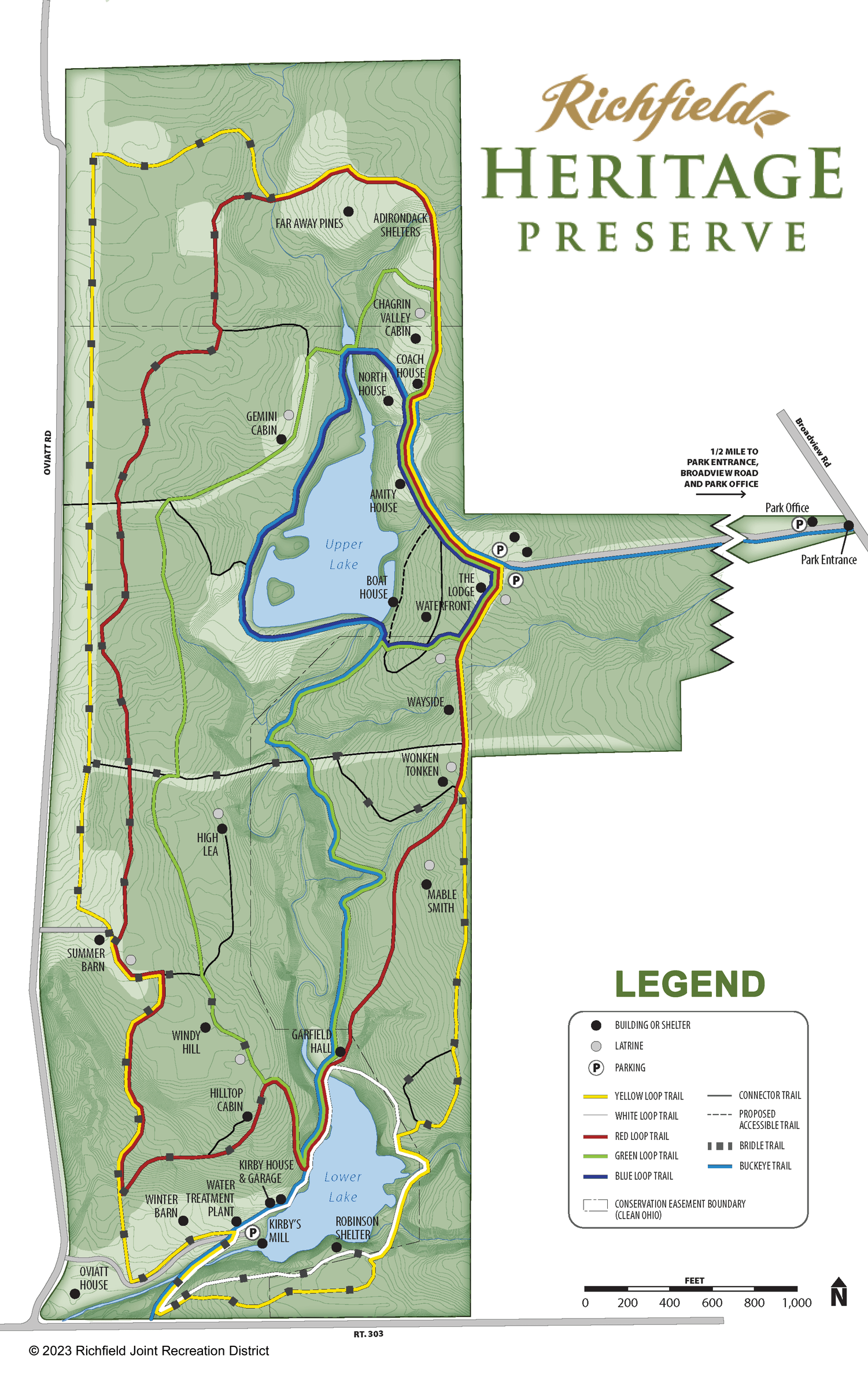
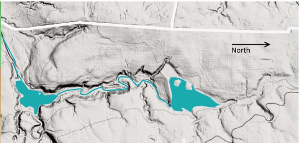
There are four maps: two maps from the website, a map I made from that map and my experiences hiking/birding, and a topographic map.
(Click on any map to open a larger version.)
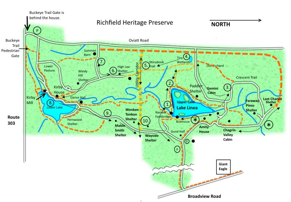
The first map is one that I created in a graphics program. It does not contain all of the labels that are on the original map from the website. I had been working on it between visits. It has the new trails marked along with a few other things that I have found in my wanderings. The white lines outlined in black are the dirt/gravel roads. The dashed lines are dirt or grass trails. I carry both maps when I go birding there.
The numbers in circles in this graphic map I made are places of interest for birding. The two asterisks in circles are additional places to look for birds. But, I wanted to create a map with a loop trail to make things a little bit easier for someone who isn’t familiar with the Preserve.
I also included a topographic map of the Preserve area. In general, to access the southern third of the Preserve, you have to go down a hill.
Important notes:
- The small restroom buildings throughout the Preserve have been cleaned and fixed up. They are checked and maintained weekly.
- A lot of the trails are roads but even they have muddy spots. Back in the late summer when it was still hot, it was fine to wear sneakers. But, I would highly recommend waterproof hiking boots.
The numbered route:
(editor's note: these routes do not correspond with the color-coded loops on RHP's website map)
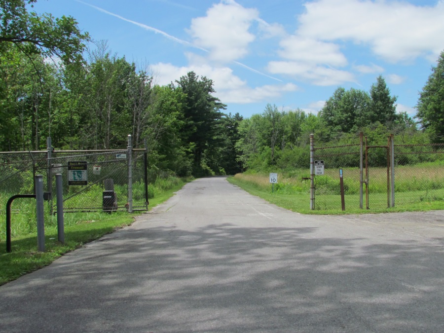
#1 Walk from the main parking area off Broadview Road. If you want a map from the Preserve, go across the road you drove in on from the main parking area and check the building near the smaller parking area for volunteer workers. The maps are in a plastic box on the wall of the building. They have some information about the historical areas in the Preserve and the volunteer efforts going on to clean up the area. If you are interested in helping out, there is contact information on the Preserve’s map. You may also run into some volunteers during your visit to the area.
The first stop is the Upper Lake area. When you come out of the woods, you will see the boat dock. There may be fishermen there. If there aren’t, scan the area around the dock. Note: Right now, all boats are prohibited on the lake.
Walk over the narrow metal footbridge over the dam. As soon as you get to the end of the bridge, look to the left in the field and the edge of the woods for birds. Then, continue along the wall along the south end of the lake. Look north and scan the lakeshore. I have seen herons and wood ducks here.
#2 This is one of the best areas I have found for seeing birds. You should walk north slowly at this point and look for movement on the island, in the plants in the water between the island and the shore, on the edge of the woods, and in the field to your left. It seems like the migrants exit the woods here and forage.
Next, walk the trail along the edge of the woods to the southwest. Look and listen for birds. Don’t go too far into the trees. Return to the area near the island.
Slowly walk into the woods along the west edge of the lake. There may be birds around you. Listen for them. This is where I have seen the most red-breasted nuthatches at close range. If you see or hear them, stop walking. They don’t seem to mind people and may come quite close. The chickadees may also come down to see you.
You will see the Paddler Shelter in a clearing on your left as you continue. You may hear towhees in this area. Be sure to look towards the lake along this trail. There are breaks in the trees where you can see the water.
#3 When you get to the end of the trail along the lake, turn left on the road. There should be trail signs on this road. You want to head to the Crescent Trail. Once you start walking west on the Crescent Trail before the first sharp turn to the right, start looking and listening for birds. They seem to be at this corner in the trail. Don’t go too far around the turn. The trail is very wet and muddy here because the trees shade it.
#4 After visiting the Crescent Trail area, return to the intersection and walk south past the Gemini Cabin. Continue on this road as it curves to the west. Keep going until you see the power lines ahead of you. Check the open areas for birds. There is a very small marshy area on the south side of the trail. Be careful as this is also an area where the volunteers are temporarily dumping a lot of debris.
#5 Walk back down the road and find the trail south into the woods. This is the Storybook Trail. Walk and listen. There are some big conifers along this trail. Listen for red-breasted nuthatches and watch for Cooper’s hawks. When you get to the wide utility cut, check the edges of the woods along the wide grassy area. There should be a section on the southwest corner of where the trail re-enters the woods. It is an open area in the woods with some dead trees that probably have some birds.
#6 Continue through the woods going south. When you get to the obvious High Lea Shelters, walk around the area and listen for birds. Just to the south of these shelters along the trail is an open area of woods where I have seen a lot of birds. I usually sit in the shelter to take a break and scan the open area in the distance with my binoculars.
#7 Continue along the trail and take the first turn to the right towards the Summer Barn. As soon as you turn right off the main trail, look at the areas along the trail, especially to the right. Continue to the Summer Barn area. There may be bluebirds, wrens, and other birds.
Return to the main road/trail and continue south. You can also walk the bridle trail south through the woods. The entrance to the bridle trail is along the path to the Summer Barn.
The next stop is Lower Lake which is currently drained. If you take the main road/trail, you want to look for the Windy Hill Shelter on your right. After this area, watch for a very faint trail off to your left. This trail is not well marked at the top of the hill. Once you get on it, it is more obvious. If you miss this side trail, you will continue down the hill along the wider road/trail.
If you took the bridle trail or the main road/trail to the bottom of the hill, check the conifers at the edge of the woods as I have seen some birds in them. As you get out into the Lower Pasture, you will see the gate to Oviatt Road. There is a hikers’ gate behind the old house for the Buckeye Trail. If you do park off Route 303 at this point, use the gate for the Buckeye Trail as it is always open.
From this point, make your way up the slight slope toward Lower Lake. I walked the edge of the field on the left. The edge of the woods may have some birds.
#8 Whichever way you used to get to Lower Lake, walk the road/trail along the lake slowly. This is another area that I found was very good for birds. You will probably hear both kinds of nuthatches. Check the island (right about where the “8” is on the map) for sparrows and others. There has been a pair of juncos in that area.
If you visit this area in the morning, the sun will probably give you some problems as it shines from the other side of the lake. But, the adjustments you have to make are worth the effort to find the birds. I saw several migrant warblers at close range along this road.
If you scan the drained lake you can see that it is being covered by plants. But, there are still some muddy areas and pools of water in addition to the creek that flows through it.
There is a trail around the other side of the lake. It enters the woods near the mill. It gives you a better overview of the lake. You have to walk up a hill to get there and you will be looking through openings in the trees. But, the morning sun is not a problem.
If you look at the maps, you can see a creek that empties into the lake on the other side. There is a nice little waterfall along this creek at one point that is worth checking out.
I usually walk back and forth along the lake a few times before heading back toward the parking area. When you get to the end of the lake, you can take the Buckeye Trail through the woods (behind the dance hall). It is more scenic than the road as it follows the creek from Upper Lake.
#9 If you take the main road/trail back towards the parking area, be sure to check every opening in the woods where there are shelters and where the utility corridor cuts through at number 10. If migrants are moving through the area, you may see them in these gaps in the trees.
* * The two other areas marked with asterisks are also worth checking out. The one along the east shore of Upper Lake is very scenic. The one between the Chagrin Valley Cabin and the Last Chance Shelter also has some birds. On one visit (and only on that one visit), I saw and heard a barred owl in the conifers near the Faraway Pines Shelter area.
Other notes:
The very thick orange dashed line along Oviatt Road is the bridle trail. There are bluebird boxes along this trail that are also used by tree swallows. Some birds can be found on the edge of the woods. The power line towers sometimes have red-tailed hawks and turkey vultures. Be aware that it is mostly grass, is shaded by the edge of the woods for the morning, and can be quite wet at times.
The thinner orange dashed line that starts near Giant Eagle is the Buckeye Trail. It is more clearly marked with a yellow outline on the map from the website. The squiggly lines and white gap near Giant Eagle indicate that a section of the map has been cut out. This is the long driveway from Broadview Road to the main parking area. I have thought about walking this road. There are a few clearings in the woods. And, I have had Pileated Woodpeckers fly over the road. The Preserve only owns the land close to the road along this driveway.
As previously mentioned, I have only visited the Preserve since August of 2018. Like others, I did see a few shorebirds in the drained lake in the late summer. I have also seen some migrant warblers and kinglets in my visits. The best places to visit, in my opinion, are at numbers 2, 6 and 8.
I have seen many red-breasted nuthatches in the Preserve. I seem to see and hear them in certain spots on almost every visit including the area near Upper Lake along the west shore, in the High Lea Shelter area, and the area along the road near Lower Lake (which are numbered 2, 6, and 8).
I look forward to visiting the Preserve in all seasons to see what birds will be there. I expect the species list will grow in the future. There was an eagle’s nest just up the hill from the Kirby House. The volunteers and residents I have met in the Preserve tell me that eagles used it for a long time. The year the Preserve opened to the public, the eagles didn’t use the nest there because some great-horned owls were already on the nest when they arrived. The owls used it for several years. In the winter of 2023, I visited the area again. The nest was completely gone. Since great horned owls don't add sticks to another raptor's nest they use, it would eventually deteriorate from the weather. There have been reports of great horned owls nearby along the Carter Pedigo Trail near the Richfield Library. Maybe the owls moved there. Bald eagles have been regular nesters in Bath Nature Preserve to the south. They have been seen flying over the Preserve and occasionally perched in a tree. I am guessing that there are screech owls in the Preserve even though I have never seen or heard them. I have seen Pileated Woodpeckers and plenty of their cavities. Another birder told me that he had seen a flock of about 10 turkeys in the northwest corner of the Preserve. I only found a feather there. He also told me that he saw some at the entrance gate off Broadview Road one day.
Spring Migration Summary for 2019
There were a lot of volunteers working in many parts of the Preserve in the spring of 2019. I did not visit as much as I wanted to because of all the work going on. It was just too noisy and there were too many people there. Still, I think the tips given below for places to look for spring migrants will be helpful for future spring visits. At least it will give birders some good places to start searching.
One section of the Preserve that was worth visiting in the early spring was the first part of the bridle trail from the Lower Pasture that goes up the hill to the Summer Barn. The first section of that trail up to the thick grove of conifers had migrants. The highlight of this area was some singing Fox Sparrows which were seen and heard on multiple occasions at the very start of that section of the trail.
One of the best areas to go this spring where I found warblers, vireos, and thrushes was where the Buckeye Trail meets the utility corridor in the middle of the park. There were warblers just inside the woods along the Trail on the south side of the corridor. If you walked down the hill in the corridor to the west to the creek, there were birds just inside the woods to the south along the creek.
Birders should be aware that this stretch of the utility corridor goes down a steep, grassy hill. There are hay bales at the bottom of the hill along the creek. The bales have trapped a lot of standing water at the bottom of the hill. The walking can be very wet and slippery. Do not attempt to walk on the hay bales to get to the woods on the south side of the corridor as they are very unstable.
The Buckeye Trail which follows the creek to the north from the utility corridor also had a good number of migrating birds. This is a very scenic section of the creek that flows from the Upper Lake spillway. It is worth walking just for the views of the creek and the woods.
The west side of Upper Lake was also good for spring migrants including warblers. Some were in the wetlands in the southwest corner of the lake. Others were in the woods along the trail past the lake to where the trail meets the road.
The first section of the Crescent Trail from the road at the north end of Upper Lake also had some migrants. I only walked to where the bridle trail meets the path before the Crescent Trail turns to the north. There were sparrows, thrushes, and some grosbeaks.
I am submitting this summary in the middle of May. There may be more migrants and some summer residents coming in the near future. As of this writing, the species count for the eBird Hot Spot is 105. I am sure that this count will continue to grow in the future. There are still areas of the Preserve that have not been visited very much by birders. And, in the future, there won’t be as much construction and human activity in the spring as there was this year which should mean more bird activity.
About this Location
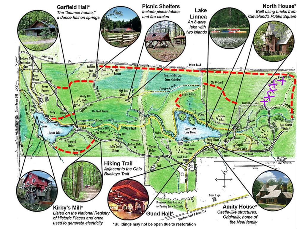
The purchase of the property, located between Broadview Road and Oviatt Road, north of Route 303, is a 336-acre park-like space. Formerly owned and operated for the past 80 years by the Girl Scouts of North East Ohio (GSNEO), Richfield Heritage Preserve offers many amenities including hiking trails and fishing. Historic buildings in the park were once owned by the Oviatt and Neal families and inventor Mr. Jim Kirby. The mill and waterwheel are on the National Register of Historic Places. It generated electric power for Kirby’s lab and workshop, a house that was originally air-conditioned by diverting spring water to flow over its roof, and a hall that was built on enormous trolley springs that bounced as people danced.
The grounds of Richfield Heritage Preserve are open seven days a week from 7 AM to 7 PM. Enter on the north side (Broadview Road, next to the Giant Eagle). The buildings are not yet open, and other areas are also closed for safety reasons.
The small restroom buildings throughout the Preserve have been cleaned and fixed up. They are checked and maintained weekly.
There is a drinking fountain near the main public parking lot off Broadview Road. It has a basin for dogs and a water bottle filling station.
Features
Restrooms on site
Wheelchair accessible trail
Entrance fee
Content from Official Website
Last updated January 21, 2024