Great Seal SP--Sugarloaf Mountain Area
Great Seal SP--Sugarloaf Mountain Area
Chillicothe, Ohio 45601
Great Seal State Park Official WebsiteGreat Seal State Park map
About this Location
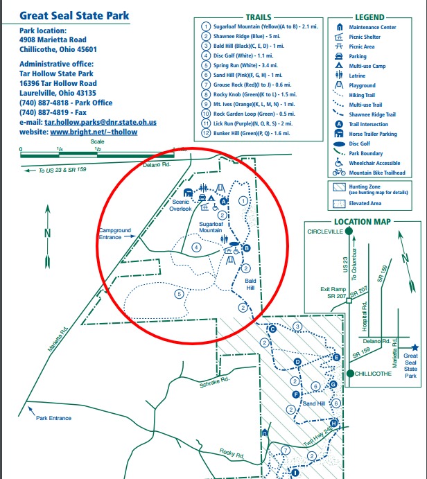
The Sugarloaf Mountain Trail (yellow), 2.1 miles, climbs through dense maple-dominated forests to the crest of Sugarloaf, which rises almost 500 feet in less than a quarter mile.
About Great Seal State Park
See all hotspots at Great Seal State Park
Ancient history is recorded in the sandstone hills that comprise the 1,862-acre Great Seal State Park. It lies upon the Appalachian escarpment, a line of hills stretching across Ohio’s midsection which outlines the edge of the Appalachian plateau in the state. North and west of the line are glaciated plains while south and east rugged hills extend to the foothills of the mountains. This definition is obvious from the trails in the park where one can see Columbus on a clear day to the north and unbroken forested ridges to the south.
These sharply etched ridges harbor a fine stand of hardwoods. Due to the underlying rock strata, one unexpectedly finds chestnut oaks on the slopes and sugar maples on the crests of the hills where the opposite is more common. Spring wildflowers are abundant in the moist coves, while papaws and persimmons entice wildlife in autumn.
Great Seal State Park is located just north of the town of Chillicothe where the history of Ohio and the culture of the Indian shroud the land. In the mid to late 1700s, the Scioto River Valley was the home of the Shawnee. Three Shawnee towns, all named Chillicothe, were located just below the hills that comprise Great Seal State Park. North of here was the intersection of five major Indian trails. The Scioto River was utilized by the Shawnee as their primary means of transportation from one village to another. The great Shawnee warrior Tecumseh was born north of here near what is now Circleville. Not far from the park is where Logan, chief of the Mingoes, gave his most eloquent speech ending his vengeance against the white settlers for murdering all his relatives.
The first settlers came to the area in the 1790s. In 1796, General Nathaniel Massie, a well-known surveyor, and woodsman, organized the settlement of the Scioto Valley by laying out on his own land the beautiful town of Chillicothe. Chillicothe was the first capital of the new state of Ohio from 1803 to 1810. (The capital was moved to Zanesville from 1811 to 1812 and then back to Chillicothe until it was permanently moved to Columbus in 1816.)
The park takes its name from the state emblem, “The Great Seal of the State of Ohio.” The famous seal depicts a sheaf of wheat representing Ohio’s agricultural strength and a bundle of seventeen arrows shows Ohio to be the 17th state to enter the Union. The mountains and rising sun signify that Ohio was one of the first states west of the Alleghenies. The Scioto River flows between Mount Logan and the cultivated fields in the foreground. The design is said to have been the cooperative inspiration of Thomas Worthington, “Father of Ohio Statehood;” Edward Tiffin, the first governor; and William Creighton, first secretary of state. After an all-night meeting at “Adena,” the magnificent estate of Worthington, they viewed the sun rising over Mt. Logan and the hills of what is now Great Seal State Park thus inspiring the scene of the Great Seal of the State of Ohio.
Features
Restrooms on site
Entrance fee
Content from Great Seal State Park Official Website