Turtle Creek Bay
Oak Harbor, Ohio 43449
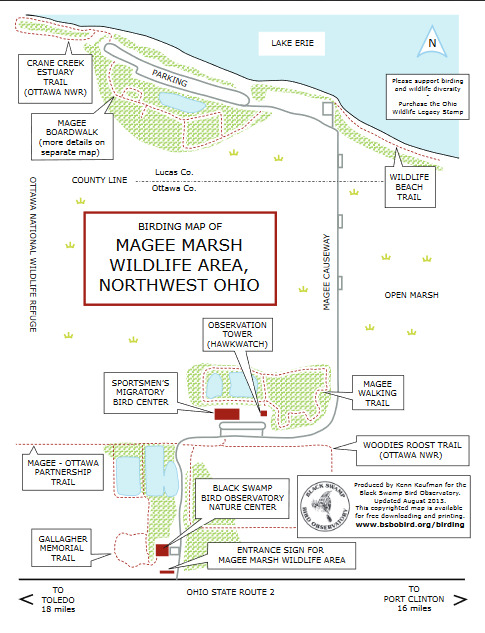
Magee Marsh Wildlife Area webpage
Magee Marsh Wildlife Area map and trails
Also, see Magee Marsh Wildlife Area
Lake Erie Western Basin Important Bird Area
eBird Bar Charts by Season
Entire Year
Turtle Creek Bay (restricted access)
Coordinates: 41.609433, -83.141696
eBird links: Hotspot map – View details – Recent visits
My eBird links: Location life list – Submit data

About Turtle Creek Bay
This hotspot is within Magee Marsh Wildlife Area, but should not be used to submit checklists for birds observed at other locations at Magee Marsh.
Tips for birding Magee Marsh Wildlife Area
Magee Marsh is a stop on the Lake Erie Birding Trail.
Magee Marsh Boardwalk Code of Ethics
From Ohio Ornithological Society website
From Birding Magee Marsh website
Tips on submitting eBird checklists at Magee Marsh
About Magee Marsh Wildlife Area
Magee Marsh Wildlife Area attracts birders from all over the world. There are a number of Hotspots set up in eBird to receive your bird checklists when you visit.
Magee Marsh is one of those locations in Ohio where a county line runs right through the middle of the area! Thus, there is no “general” hotspot for all of Magee Marsh. There are eBird Hotspots for each county. The south portion of Magee Marsh Wildlife Area (near OH-2) is in Ottawa County. The north portion of the wildlife area (near Lake Erie) is in Lucas County. (See map below for the location of the Lucas/Ottawa county line.)
Restrooms at Magee Marsh are available inside the Migratory Bird Center. Portable toilets are at the Black Swamp Bird Observatory office all year and seasonally at the parking lot for the Magee Marsh boardwalk.