Kokosing Gap Trail--Lower Gambier Rd.
Kokosing Gap Trail--Lower Gambier Rd.
Mount Vernon, Ohio 43050
Kokosing Gap Trail Official WebsiteKokosing Gap Trail map
Also, see all the hotspots at:
Knox County Birding Drive
About this Location
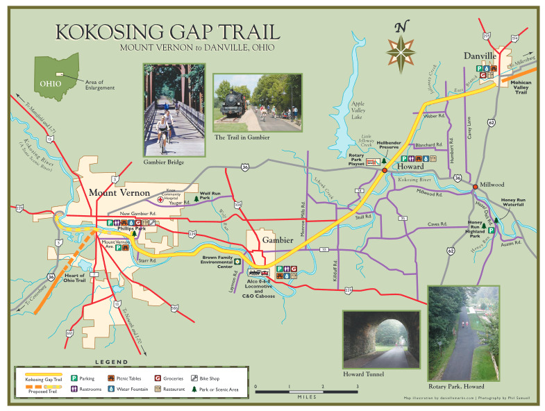
There is parking for the Kokosing Gap Trail on Lower Gambier Road.
About Kokosing Gap Trail
See all hotspots at Kokosing Gap Trail
The Kokosing Gap Trail is a paved, 14-mile recreational trail built on a former Pennsylvania Railroad line with endpoints in Mount Vernon and Danville, Ohio.
Visitors will traverse the Kokosing River twice on railroad bridges more than 250 feet long, with forests, wetlands, agriculture, and villages along the way. Awesome flora and wildlife make it a great way to commune with nature and shape up at the same time! A 1940 Alco 0-6-0 locomotive and a 1924 Chesapeake & Ohio caboose sit next to the Trail in Gambier and a wonderful park with a play structure is adjacent to the Trail in Howard.
Water fountains and restrooms are available on the Trail in Mount Vernon, Gambier, and Howard. In Danville, facilities are in Memorial Park. Water is turned off and restrooms are closed from mid-November to mid-April. The Howard restroom is open all year. Park benches are located along the Trail about every .5 mile, and a public phone is available at the shelter in Gambier.
The Trail is open 24 hours a day, 365 days a year. It is the largest, paved rail-to-trail park in the United States maintained solely by donations and volunteers.
Features
Restrooms on site
Wheelchair accessible trail
Content from Kokosing Gap Trail Official Website