Mount Airy Forest
Mount Airy Forest
5083 Colerain Avenue Cincinnati, Ohio 45223
Mount Airy Forest Official WebsiteMount Airy Forest map
Also, see all the hotspots at:
Cincinnati Birding Drive
About this Location
It is most helpful when submitting eBird observations at Mount Airy Forest to start a new checklist for each hotspot within the park. Use this general hotspot when you have a checklist that includes multiple locations or there was not a hotspot or personal location appropriate for your sightings.
About Mount Airy Forest
See all hotspots at Mount Airy Forest
At almost 1,500 acres, Mount Airy Forest is Cincinnati’s largest park. It was established in 1911 out of several unproductive farms and was the first municipal reforestation in America. A crew of young African Americans was employed by the Civilian Conservation Corps (a federal jobs program during the Great Depression) to build service roads, the large check dams in West Fork Creek and, along with more skilled laborers working for the Works Progress Administration, most of the shelter, service and restroom buildings. They also planted more than one million trees! Each recreational area typically included a shelter, comfort station, picnic tables, and a water source, either a fountain or a pump.
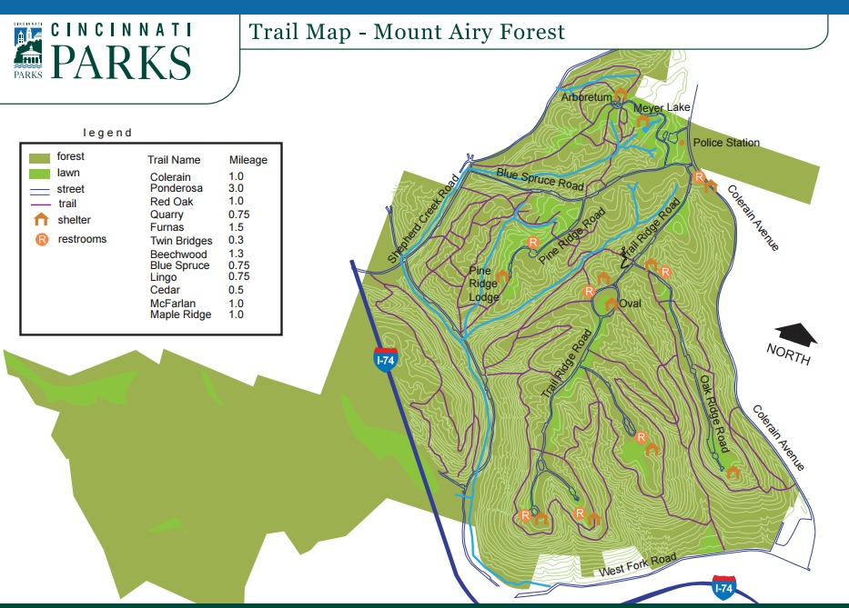
Notable Trails
Mount Airy Forest Trails
Hiking trails at Mount Airy Forest include:
Colerain Trail – 1 mile
Ponderosa Trail – 3 miles
Red Oak Trail – 1 mile
Quarry Trail – 0.75 miles
Furnas Trail – 1.5 miles
Twin Bridges Trail – 0.3 miles
Beechwood Trail – 1.3 miles
Blue Spruce Trail – 0.75 miles
Lingo Trail – 0.75 miles
Cedar Trail – 0.5 miles
McFarlan Trail – 1 mile
Maple Ridge Trail – 1 mile
Descriptions with maps of hikes on trails at Mount Airy Forest are on the AllTrails website.
Features
Restrooms on site
Wheelchair accessible trail
Entrance fee
Roadside viewing
Content from Mount Airy Forest Official Website
Last updated February 5, 2023